Urban City Zoning Interface | GIS Platform Modernization
A strategic UX and product design initiative focused on modernizing a legacy zoning and land-use intelligence platform used by city planners, analysts, developers, and the public. The work balances regulatory complexity with usability, accessibility, and operational efficiency across desktop and mobile environments.
View Case Study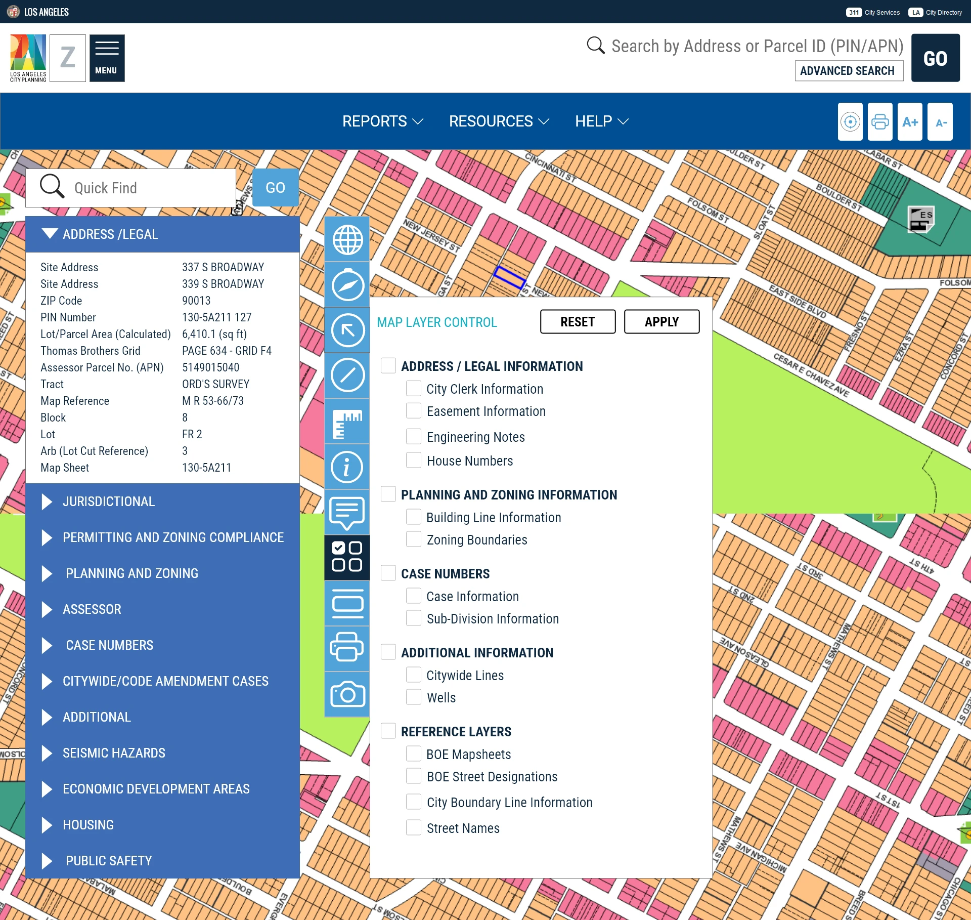
At a glance
Operational efficiency
Reduced cognitive load and task time for planners working with dense zoning layers, parcel data, historical overlays, and compliance constraints by restructuring navigation, search, and map tooling around real planning workflows.
Accessibility and equity
Improved discoverability and comprehension for non-expert users by introducing flexible search patterns, filter-as-you-type behavior, and clearer information hierarchy without removing expert-level functionality.
Future-ready platform
Designed a scalable, responsive system that supports desktop-heavy professional use while extending access to mobile contexts such as field work, community meetings, and on-the-go research.
Context
Zoning systems are decision infrastructure.
Zoning and land-use platforms are not simple reference tools. They sit at the intersection of legal compliance, urban planning, public transparency, and economic development. When these systems are hard to use, decisions slow down, errors increase, and institutional knowledge becomes siloed. This project treated the platform as civic infrastructure, designing for clarity, speed, and confidence in high-stakes decision-making.
Design principles
Respect existing workflows
The platform already supported complex regulatory tasks. The goal was not disruption, but evolution. Every change builds on established planning workflows to reduce adoption risk and protect institutional trust.
Reduce cognitive load
Planners regularly juggle zoning codes, overlays, parcel boundaries, transit layers, and historic districts. The interface was redesigned to help users see, prioritize, and act faster.
Design for inclusion
Public systems must serve experts and first-time users. Flexible search logic and forgiving discovery patterns ensure that people can find information even when they do not know exact internal terminology.
Key interventions
Turning a legacy GIS tool into a modern civic product
Mega menu for complex systems
Introduced a structured mega menu to surface reports, planning data, environmental layers, and reference tools in a single, scannable view. This significantly improves discoverability of underused but high-value features and reduces time spent hunting through nested menus.
Advanced, multi-path search
Designed a unified advanced search framework that supports address, parcel number, legal description, case number, council district, and neighborhood-based queries. This mirrors how different departments actually think about land, not how databases are structured.
Quick find and anticipatory search
Implemented filter-as-you-type behavior to help users locate data even when naming is inconsistent or partially remembered. This is especially important in public-facing systems where institutional vocabulary is not shared.
Map tooling aligned to mental models
Reorganized map navigation, parcel selection, radius measurement, and background layer controls using patterns familiar from modern mapping tools. This reduces training overhead and lowers error risk in spatial analysis.
Responsive strategy
Designed for the hardest screen first
Although most professional users operate on desktop, the platform was intentionally designed within mobile constraints first. This ensures long-term scalability and supports real-world usage scenarios such as field inspections, public meetings, and community engagement. Designing for constraint early prevents costly retrofits later.
Impact for cities and institutions
Faster decisions
Reduced friction in research and analysis workflows enables planners to answer zoning and compliance questions faster, accelerating approvals and internal reviews.
Lower onboarding cost
Clearer navigation and discoverability reduce dependency on tribal knowledge, making it easier to onboard new staff and cross-functional teams.
Public trust and transparency
When zoning data is easier to access and understand, public confidence increases and friction between residents, developers, and city staff is reduced.
Disclosure
Conceptual work shown for public viewing
This case study highlights design strategy, system thinking, and UX decision-making in regulated civic environments. Screens and workflows are selectively abstracted for confidentiality. Deeper technical and implementation detail is available in interviews.